
Travel Tuesday Part 6: GPS and Getting Around
Welcome to your destination! Can’t believe we’ve helped you plan over the last few weeks! Now how the heck do you get around? Why, GPS of course!
 The ability to have GPS technology in our mobile phones is one of the most convenient amenities of today. Here are some apps that use GPS effectively to help you get around, at home or while you travel:
HopStop
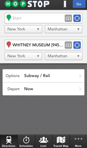
Hopstop is one of my favorite apps available. Available in major (and some minor) cities all over the world, it enables you to get around using public transportation. Featuring subway, rail, bus, bicycle, or even walking directions, it is the easiest way to get around by far if you haven’t got a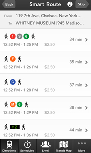 car rental. Simply type in the address you’re leaving from and the address you are headed to, and it will give you as many options as are available. General transit maps and schedules are also available in the app. This app is especially useful for when you don’t feel like standing in a public place, ogling a map like a complete tourist.
Waze
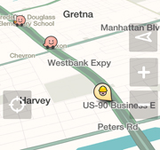 Waze is one of my favorite driving apps of all time. If you have a car rental, or are taking a roadtrip, this app is a necessity. I use it in my hometown, but find it far more useful in new cities. Once you sign up for Waze, you are given a little icon. They have different icons for new users and for veteran users. Once you drive for a while with the app you can unlock new icons, post your mood, and even add “friends” to your account. All of that is a little much for me, so my main focus is the navigation aspect. You can type in your destination to get
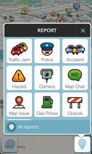
directions just like a normal navigation app, but Waze provides so much more. First, it shows you where all of the traffic cameras in the area are – especially helpful for not getting a ticket. Also, it shows you where there are car accidents, and even where there are police. You can also see where there is roadwork or there
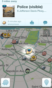
are lane blockages. Waze is user supported, so it is also up to you to help report sightings. You can report where you see a sitting speed trap, and say whether the officer is hidden or visible. You can then take a picture, or not, and post it to the map for others to see. Of course, none of this should be done while you are actually driving! I love this app because it helps me get around new cities like a local, by helping me avoid silly driving mistakes.
Hailo
Available in major cities of the US, Europe & Asia right now, Hailo is similar to Uber, but more fair to existing cab drivers, and wont
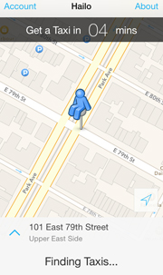
surprise you with ridiculous surge pricing. Hailo is the world’s easiest way to hail a cab. You open the app, allow it access to your location, and it gives you a time estimate, and hails your cab. It works with the city’s existing cab infrastructure so itdoesn’t disrupt the local economy, and you wont see 14 yellow cabs fly by while you’re waiting for the one you e-hailed. Though the app doesn’t process payments yet, but no matter. That’s never the hard part.
Enjoy-o.
The Bar Code News is grateful for all of the material we receive from industry experts and can share with our readers. If you've found this article worthwhile, please share with others in your organization, and be sure to let our contributors and sponsors know you've seen them on www.barcode.com.
Subscribe to The Bar Code News - get it daily, once a week or once a month. We respect your privacy and never sell or rent our list.
Click to visit our Facebook page.
We appreciate your visiting us, and would love to be "Liked" by you.
Other Articles You May Like:
Travel Tuesday Part 2: Smartphone Travel App Reviews: Booking Accommodations
NFC For Luggage - No More Lost Baggage
Travel Tuesday Part 4: Smartphone Travel App Reviews: Detail Organization